
How far is Lake Tahoe from home? From most of the Reno, Sparks, Carson City and Carson Valley communities on this site, the honest answer is under an hour, but it depends on which shore you mean, which pass sits in between and what month it is. A house in south Reno and a house in Minden can both be described as "near Tahoe" and still point you toward opposite ends of the lake.
Published answers usually give one number for a whole city. On October 23, 2026, I built a road model from OpenStreetMap, the open map database maintained by volunteers (road data © OpenStreetMap contributors), and used it to route 78 trips, from 13 starting points across Washoe, Lyon, Douglas and Carson City to six shoreline destinations on both the Nevada and California sides. Every trip ran twice, once at posted speed limits and once at a more conservative pace, so each time is a range. I then sampled USGS elevations along the main routes and checked the model's state-route mileages against NDOT's official log. These are free-flow baselines; real trips run longer. For life at the lake itself, start with our guide to moving to Lake Tahoe, Nevada.
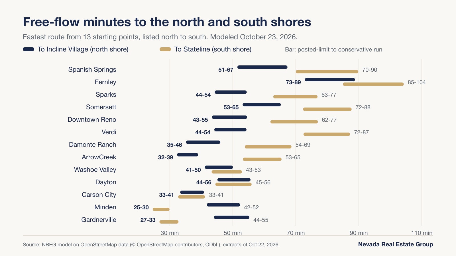
Twelve of our 13 starting points reach the nearest of six Lake Tahoe destinations in 25 to 67 free-flow minutes. Minden reached Stateline in 25 to 30 minutes, Carson City reached Sand Harbor in 27 to 32, ArrowCreek reached Incline Village in 32 to 39 and downtown Reno reached Incline in 43 to 55; Fernley needed 73 to 89. Winter is the variable: four of five main routes cross passes between about 7,100 and 8,900 feet.
- ArrowCreek and Damonte Ranch reach Incline Village in 32 to 39 and 35 to 46 minutes over Mt. Rose.
- Carson City sits 27 to 33 minutes from Sand Harbor and Zephyr Cove by U.S. 50 over Spooner Summit.
- Minden and Gardnerville reach Stateline in 25 to 30 and 27 to 33 minutes over Kingsbury Grade.
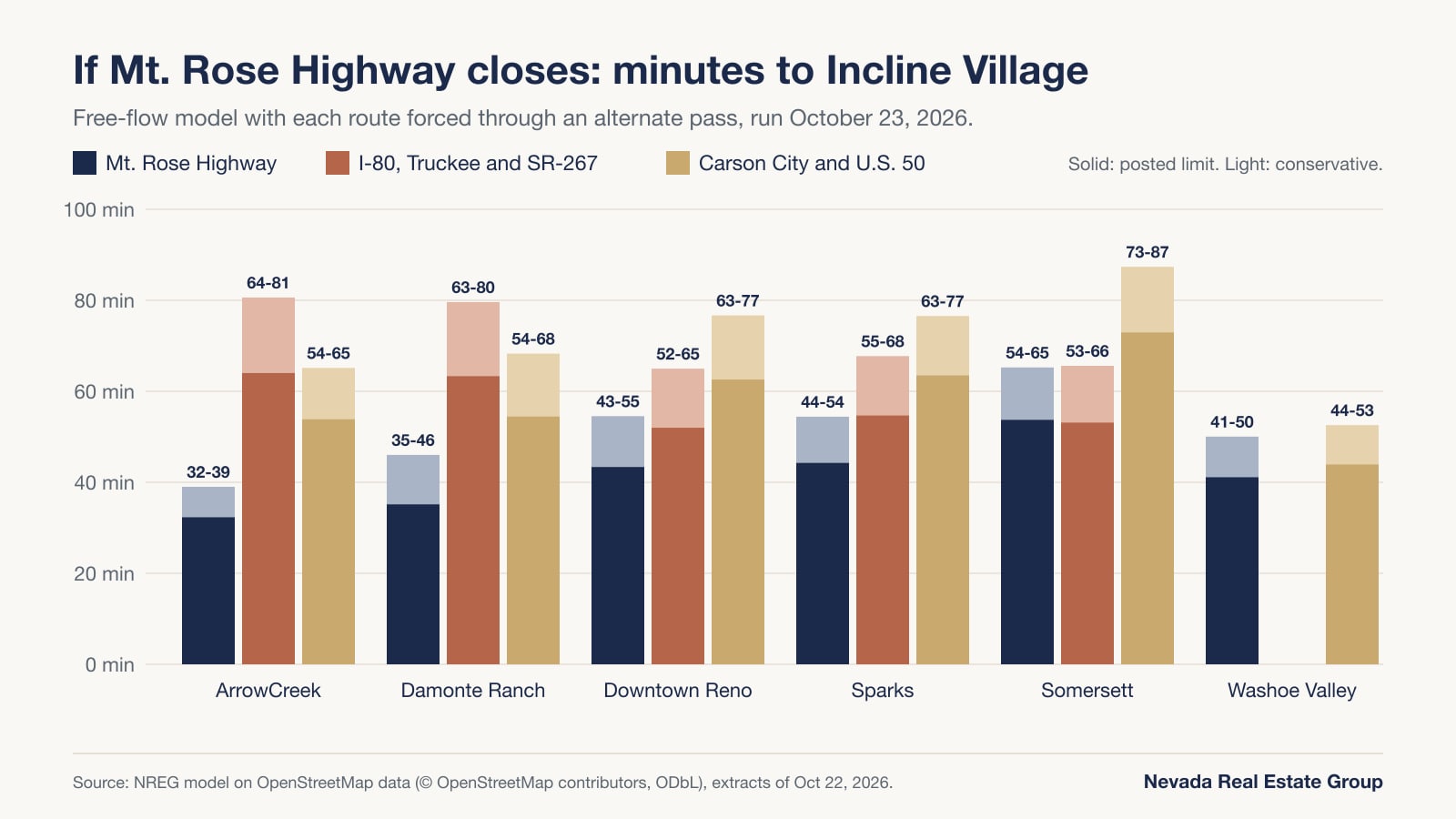
- If Mt. Rose closes, downtown Reno to Incline Village grows from 43–55 to 52–65 minutes via Truckee.
- Nevada's chain controls on SR-431, SR-207 and part of U.S. 50 admit only chains or 4WD/AWD with snow tires.
| Starting point | Incline Village, NV | Kings Beach, CA | Tahoe City, CA | Sand Harbor, NV | Zephyr Cove, NV | Stateline, NV |
|---|---|---|---|---|---|---|
| Downtown Reno | 43–55 min, 36.3 mi | 43–55 min, 42.9 mi | 48–58 min, 46.8 mi | 48–60 min, 39.1 mi | 56–69 min, 53.9 mi | 62–77 min, 57.8 mi |
| Somersett, northwest Reno | 53–65 min, 46.8 mi | 45–55 min, 41.9 mi | 49–59 min, 45.9 mi | 58–71 min, 47.7 mi | 67–80 min, 62.5 mi | 72–88 min, 66.4 mi |
| Verdi | 44–54 min, 38.1 mi | 36–44 min, 33.2 mi | 40–48 min, 37.1 mi | 51–62 min, 42.3 mi | 67–79 min, 64.7 mi | 72–87 min, 68.6 mi |
| Damonte Ranch, south Reno | 35–46 min, 27.8 mi | 41–53 min, 31.0 mi | 56–71 min, 40.7 mi | 40–51 min, 30.6 mi | 48–61 min, 46.0 mi | 54–69 min, 49.8 mi |
| ArrowCreek, southwest Reno | 32–39 min, 24.9 mi | 38–46 min, 28.1 mi | 53–64 min, 37.9 mi | 37–44 min, 27.8 mi | 48–57 min, 44.3 mi | 53–65 min, 48.2 mi |
| Sparks (Victorian Square) | 44–54 min, 37.9 mi | 46–57 min, 46.2 mi | 50–61 min, 50.2 mi | 49–60 min, 40.7 mi | 57–69 min, 55.5 mi | 63–77 min, 59.4 mi |
| Spanish Springs | 51–67 min, 44.5 mi | 54–71 min, 52.9 mi | 58–75 min, 56.9 mi | 56–73 min, 47.3 mi | 64–82 min, 62.1 mi | 70–90 min, 66.0 mi |
| Fernley | 73–89 min, 64.2 mi | 76–92 min, 77.2 mi | 80–96 min, 81.1 mi | 78–94 min, 67.0 mi | 79–96 min, 70.9 mi | 85–104 min, 74.8 mi |
| Washoe Valley | 41–50 min, 34.6 mi | 47–57 min, 37.9 mi | 62–75 min, 47.6 mi | 37–44 min, 33.0 mi | 38–45 min, 33.5 mi | 43–53 min, 37.3 mi |
| Carson City | 33–41 min, 25.2 mi | 42–50 min, 29.6 mi | 57–69 min, 39.4 mi | 27–32 min, 20.5 mi | 27–33 min, 21.0 mi | 33–41 min, 24.9 mi |
| Dayton | 45–56 min, 36.9 mi | 53–65 min, 41.2 mi | 68–83 min, 51.0 mi | 38–47 min, 32.1 mi | 39–48 min, 32.6 mi | 44–56 min, 36.5 mi |
| Minden | 42–52 min, 34.4 mi | 50–62 min, 38.7 mi | 65–80 min, 48.5 mi | 35–44 min, 29.6 mi | 29–35 min, 20.4 mi | 25–30 min, 17.3 mi |
| Gardnerville | 44–55 min, 35.6 mi | 52–65 min, 39.9 mi | 67–83 min, 49.7 mi | 37–47 min, 30.8 mi | 31–38 min, 21.3 mi | 27–33 min, 18.2 mi |
How far is Lake Tahoe from each Reno and Carson City area community?
Read the table by row and one pattern jumps out: the lake is two destinations, not one. Starting points in the Truckee Meadows are closest to the north shore, starting points in Carson City and Carson Valley are closest to the east and south shores, and from nine of the 13 starting points, Incline Village and Stateline sit about 17 to 33 minutes apart in drive time.
From downtown Reno, Kings Beach and Incline Village are a dead heat at 43 to 55 minutes, but by different roads: Kings Beach comes via Interstate 80 and SR-267 through Truckee (42.9 miles), Incline via the Mt. Rose Highway (36.3 miles). Tahoe City is 48 to 58 minutes and Stateline 62 to 77. The south Reno communities sit closest to the Mt. Rose Highway, so they lead the Reno list: ArrowCreek reached Incline Village in 32 to 39 minutes and Damonte Ranch in 35 to 46. Sparks and Spanish Springs add the cross-town leg, at 44 to 54 and 51 to 67 minutes to Incline.
Carson City is the hinge of the region. It reached Sand Harbor in 27 to 32 minutes, Zephyr Cove in 27 to 33, and both Stateline and Incline Village in 33 to 41, so both shores are within about 40 minutes. Farther south, Minden and Gardnerville reached Stateline in 25 to 30 and 27 to 33 minutes over Kingsbury Grade, the shortest trips in the whole table. Dayton and Washoe Valley land in the middle, at 38 to 47 and 37 to 44 minutes to Sand Harbor.
The gap between shores is the number to remember: downtown Reno to Stateline is about 19 to 23 minutes longer than to Incline Village, and Minden to Incline is about 17 to 22 minutes longer than to Stateline. Only Carson City, Dayton and Washoe Valley sit near the middle, where Incline Village and Stateline are within about three minutes of each other.
How did we measure these drive times?
Every time in the main table comes from one road model that I built and ran myself. The road data is OpenStreetMap, © OpenStreetMap contributors. According to the OpenStreetMap copyright page, the data is licensed under the Open Database License and may be reused as long as OpenStreetMap and its contributors are credited. On October 23, 2026, I downloaded Geofabrik's Nevada and Northern California extracts, both containing OpenStreetMap data through October 22, 2026, and kept every public road a car can use inside a box running from just south of Gardnerville to north of Spanish Springs and from west of Truckee to east of Fernley: about 28,000 road segments. Roads tagged private or closed to cars were left out, and one-way streets, freeways and roundabouts stayed one-way. I built a directed graph of those roads with the open-source NetworkX library and found the fastest path for each of the 78 pairs with its Dijkstra shortest-path routine.
Speed comes from the speed limit tagged on each road in OpenStreetMap. Where a road carried no limit, the model used a default for its class: 65 mph on freeways, 55 on other major highways, 45 on primary roads, 40 on secondary, 35 on tertiary, 30 on unclassified roads and 25 on residential streets, with lower speeds on ramps. Tagged limits covered at least 94% of the driving distance on 75 of the 78 trips; the lowest coverage, 81%, was Gardnerville to Stateline.
Each trip ran twice. The posted-limit run assumes every road is driven at its limit with no stops, which is a best case. The conservative run drives at 85% of each limit and adds 20 seconds at every traffic signal. Neither run models traffic, weather, chain controls, grades, turns, stop signs or parking, and both speed settings are my assumptions, not measurements of real drives. Each point is a named public landmark, listed below, so a home elsewhere in the same community can be several minutes closer or farther.
| Point | Landmark used | Latitude, longitude |
|---|---|---|
| Downtown Reno | Reno Arch | 39.52813, -119.81366 |
| Somersett | Somersett Golf and Country Club | 39.53458, -119.93132 |
| Verdi | Verdi Community Library | 39.52195, -119.99015 |
| Damonte Ranch | Damonte Ranch Park | 39.42501, -119.72649 |
| ArrowCreek | ArrowCreek Parkway | 39.40454, -119.76717 |
| Sparks | Victorian Square | 39.53503, -119.75596 |
| Spanish Springs | Spanish Springs Library | 39.62085, -119.72467 |
| Fernley | Fernley City Hall | 39.60472, -119.24048 |
| Washoe Valley | Bowers Mansion | 39.28455, -119.84134 |
| Carson City | Nevada State Capitol | 39.16390, -119.76615 |
| Dayton | Dayton town center (OSM place point) | 39.23623, -119.59041 |
| Minden | Minden town center (OSM place point) | 38.95330, -119.76366 |
| Gardnerville | Gardnerville town center (OSM place point) | 38.94151, -119.74935 |
| Incline Village | Incline Village Library | 39.25035, -119.95748 |
| Kings Beach | Kings Beach (OSM place point) | 39.23628, -120.02336 |
| Tahoe City | Fanny Bridge | 39.16682, -120.14436 |
| Sand Harbor | Sand Harbor beach | 39.19869, -119.93196 |
| Zephyr Cove | Zephyr Cove (OSM place point) | 39.00601, -119.94724 |
| Stateline | Stateline (OSM place point on U.S. 50) | 38.96307, -119.93995 |
How accurate is the model?
Two checks show how far to trust it. The first is distance, and here there is an official answer. NDOT publishes the length of every state route it maintains. According to NDOT's January 2023 Description Index, SR-431, the Mt. Rose Highway, runs 24.461 miles from SR-28 to South Virginia Street; SR-207, Kingsbury Grade, runs 11.073 miles from U.S. 50 to Foothill Road; and SR-28 runs 16.166 miles from U.S. 50 to the California line across its Douglas County, Carson City and Washoe County segments. Measured in the model, the same three routes come out at 24.47, 11.07 and 16.16 miles, each within about a hundredth of a mile. The road network and distances in the model are sound on the routes that matter most here.
The second check is time, and there is no official number to compare against, which is why every time in this guide is a range. The posted-limit run is the floor. The conservative run came out 19% to 32% longer, with the biggest gaps on trips through the most traffic signals, such as those from Spanish Springs and Damonte Ranch. As one outside reference, the North Lake Tahoe Express flyer covered below asks north-shore riders to allow at least 1.5 hours to reach the Reno airport, a figure that includes shuttle stops. For a trip you plan to make every week, drive it yourself at the hour you would actually travel.
| State route | Section | NDOT official length | Length in our model |
|---|---|---|---|
| SR-431, Mt. Rose Highway | SR-28 in Incline Village to South Virginia Street, Reno | 24.461 mi | 24.47 mi |
| SR-207, Kingsbury Grade | U.S. 50 at Stateline to SR-206, Foothill Road | 11.073 mi | 11.07 mi |
| SR-28, Nevada section | U.S. 50 to the California state line | 16.166 mi (1.172 + 3.987 + 11.007) | 16.16 mi |
Which mountain pass does each route cross, and how high does it climb?
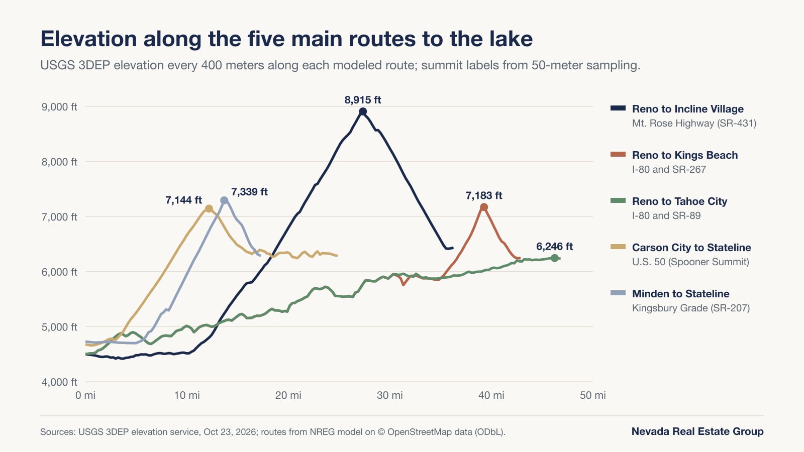
The Carson Range stands between the valleys and the lake, so almost every trip in the table climbs before it descends to the shore. Every fastest route in our results uses one of five corridors, and they top out at very different heights. According to the USGS Elevation Point Query Service, which I used to measure them, the service returns the elevation for any latitude and longitude from USGS elevation data. I queried a point every 400 meters along each modeled route, and every 50 meters around each summit, on October 23, 2026.
The Mt. Rose Highway stands apart. From about 4,500 feet at the Reno Arch, the route climbs roughly 4,400 feet to a high point of about 8,915 feet, 27 miles out, before dropping to about 6,430 feet at the Incline Village Library. Kingsbury Grade tops out near 7,339 feet, Brockway Summit on SR-267 near 7,183 feet and Spooner Summit on U.S. 50 near 7,144 feet. The fifth route, Interstate 80 to Truckee and SR-89 along the Truckee River to Tahoe City, never climbs above about 6,246 feet, and that high point is at Tahoe City itself. These are elevation-model values at the road, so a posted summit sign can show a slightly different number.
| Dimension | Mt. Rose Highway (SR-431) | U.S. 50 over Spooner Summit | Kingsbury Grade (SR-207) | I-80 and SR-267 (Brockway Summit) | I-80 and SR-89 |
|---|---|---|---|---|---|
| High point we measured | About 8,915 ft | About 7,144 ft | About 7,339 ft | About 7,183 ft | About 6,246 ft, at Tahoe City |
| Fastest route in our model for | Incline Village and Sand Harbor from most Reno-area starts and Fernley; every north-shore trip from Damonte Ranch and ArrowCreek | Every trip from Carson City and Dayton; the south shore from every start north of Carson City; the north and east shores from Minden and Gardnerville | The south shore from Minden and Gardnerville | Kings Beach from downtown Reno, Somersett, Verdi, Sparks, Spanish Springs and Fernley; Incline Village from Verdi and Somersett | Tahoe City from downtown Reno, Somersett, Verdi, Sparks, Spanish Springs and Fernley |
| State and agency | Nevada, NDOT | Nevada, NDOT | Nevada, NDOT | Nevada then California; Caltrans on SR-267 | Nevada then California; Caltrans on SR-89 |
| Winter traction rule | NDOT Tahoe rule: chains, or 4WD/AWD with snow tires | NDOT Tahoe rule between Glenbrook and Carson City | NDOT Tahoe rule: chains, or 4WD/AWD with snow tires | Caltrans R-1, R-2 or R-3 controls | Caltrans R-1, R-2 or R-3 controls |
| Storm closures cited in this guide | December 23 to 28, 2021 and February 13 to 15, 2025 | Not reviewed here | Not reviewed here | Not reviewed here | Not reviewed here |
| Where to check first | Nevada 511 | Nevada 511 | Nevada 511 | Nevada 511, then Caltrans QuickMap | Nevada 511, then Caltrans QuickMap |
Which communities are closest to Incline Village and the North Shore?
If the north shore is where you will spend most of your lake time, the Mt. Rose Highway decides the ranking, and the closer a starting point sits to its lower end in south Reno, the shorter the trip. In our model, the ArrowCreek trip reaches SR-431 by way of Thomas Creek Road without touching the freeway, and the drive to the Incline Village Library took 32 to 39 minutes over 24.9 miles. Damonte Ranch, a few miles east, took 35 to 46 minutes over 27.8 miles.
Downtown Reno took 43 to 55 minutes to Incline Village and Sparks 44 to 54, both via Interstate 580. Spanish Springs took 51 to 67 minutes because the first leg crosses the valley on Pyramid Way, McCarran Boulevard and U.S. 395. Fernley took 73 to 89, the longest north-shore trip.
Sand Harbor, the beach in Lake Tahoe Nevada State Park south of Incline Village on SR-28, adds about five minutes to any trip that comes over Mt. Rose: 48 to 60 minutes from downtown Reno, 40 to 51 from Damonte Ranch, 37 to 44 from ArrowCreek. From south Reno, even California's Kings Beach is quickest over Mt. Rose and along SR-28 through Crystal Bay, at 41 to 53 minutes from Damonte Ranch.
According to Nevada State Parks, Sand Harbor's day-use entrance fee is $10.00 per vehicle, or $15.00 for non-Nevada vehicles, and day-use reservations are required for morning vehicle entry from 8 a.m., May 15 through September 30 (the page lists both 10 and 10:30 a.m. as the cutoff); the same page says the parking lots are kept clear of snow and the visitor center is open year-round. Those terms were current as of October 23, 2026; the Incline Village community page has current listings.
Why do Verdi and northwest Reno often reach the lake fastest through California?
West of downtown, the fastest road to the lake usually is not the Mt. Rose Highway at all. From Verdi, the model sent every north-shore trip west on Interstate 80 to Truckee and then south into California. Kings Beach took 36 to 44 minutes over 33.2 miles via SR-267, and Tahoe City took 40 to 48 minutes over 37.1 miles via SR-89. Even Incline Village was faster from Verdi through Truckee and Kings Beach, at 44 to 54 minutes, than over Mt. Rose.
Somersett, in northwest Reno, sits at the tipping point. Its fastest trip was Kings Beach at 45 to 55 minutes, and its trip to Incline Village came out at 53 to 66 minutes through Truckee and SR-267 and 54 to 65 minutes over Mt. Rose, a tie in practice. That tie is worth knowing in winter: if one route is under chain controls and the other is clear, the cost of switching from Somersett is close to zero.
The I-80 and SR-89 route is also the only one in our set with no summit: the climb from downtown Reno to Tahoe City is a gradual 1,700 feet or so over 47 miles. The SR-267 route over Brockway Summit tops out near 7,183 feet.
Two cautions come with the California routes. Caltrans sets chain controls on SR-267 and SR-89, with levels that differ from Nevada's. And Kings Beach and Tahoe City are in Placer County, California, so a home there follows California tax and residency rules. Our Nevada side versus California side guide covers that decision in depth; this guide only models the drive.
Which communities are closest to Zephyr Cove, Stateline and the South Shore?
The south and east shores belong to Carson City and Carson Valley. Minden reached Stateline in 25 to 30 minutes over 17.3 miles, the shortest trip in the table, by way of SR-88 and Kingsbury Grade, SR-207. Gardnerville took 27 to 33 minutes over 18.2 miles, also over Kingsbury. Zephyr Cove, a few miles north of Stateline on U.S. 50, took 29 to 35 minutes from Minden and 31 to 38 from Gardnerville.
From Carson City, U.S. 50 over Spooner Summit is the direct line. The Capitol to Zephyr Cove took 27 to 33 minutes over 21.0 miles, and to Stateline 33 to 41 minutes over 24.9 miles. Dayton, east of Carson City on U.S. 50, took 39 to 48 minutes to Zephyr Cove and 44 to 56 to Stateline. Washoe Valley, between Reno and Carson City, took 38 to 45 and 43 to 53 minutes; its trip runs south on Interstate 580 and joins U.S. 50 in Carson City.
For Reno-area starting points the south shore is a long trip, 53 to 90 minutes to Stateline, and the model chose Carson City and U.S. 50 for all of them. Forcing downtown Reno's trip over Kingsbury Grade made it 68 to 85 minutes instead of 62 to 77, and over Mt. Rose and down SR-28, 74 to 93.
Stateline, Zephyr Cove and Glenbrook are in Douglas County, Nevada. The Stateline homes page shows current listings there, the Kingsbury Grade neighborhood page covers the hillside along SR-207 itself, and the Zephyr Cove and Glenbrook pages cover the east shore. For the Carson City side of the equation, our Carson City home-buying guide walks through neighborhoods, taxes and the purchase process.
What happens to the drive when the Mt. Rose Highway closes?
The Mt. Rose Highway is the fastest road to the north shore from most of Reno, and the highest. It closes in severe storms, and the alternatives are long. According to South Tahoe Now's December 28, 2021 report, the upper section of SR-431 between Douglas Fir Drive and Fairview Boulevard was closed from December 23 to December 28, 2021. NDOT crews worked staggered 12-hour shifts against as much as nine feet of snow and ridge-top gusts of 100 mph. According to KOLO's February 15, 2025 report, the highway reopened in both directions after a closure that began Thursday, February 13, at 3 p.m.; NDOT said the road had received around 60 inches of snow before avalanche mitigation began.
To size the detour, I forced the model through each alternate pass. For downtown Reno and Sparks, the Truckee route via I-80 and SR-267 is the better fallback, adding about 9 to 10 and 10 to 13 minutes. For south Reno it is the opposite: Damonte Ranch and ArrowCreek do better going through Carson City and over Spooner Summit, adding about 19 to 22 and 22 to 26 minutes, because the Truckee route sends them back across the valley first. Somersett loses nothing, and Washoe Valley adds about 3 minutes via Spooner. The same storm can bring chain controls to the other passes, so a free-flow detour is a floor, not a forecast.
| Trip | Normal route | Alternate route | Second alternate | Added minutes, best alternate |
|---|---|---|---|---|
| Downtown Reno to Incline Village | Mt. Rose: 43–55 min, 36.3 mi | I-80 and SR-267: 52–65 min, 47.8 mi | U.S. 50 via Carson City: 63–77 min, 58.2 mi | About 9 to 10 |
| Sparks to Incline Village | Mt. Rose: 44–54 min, 37.9 mi | I-80 and SR-267: 55–68 min, 51.2 mi | U.S. 50 via Carson City: 63–77 min, 59.8 mi | About 10 to 13 |
| Damonte Ranch to Incline Village | Mt. Rose: 35–46 min, 27.8 mi | U.S. 50 via Carson City: 54–68 min, 50.2 mi | I-80 and SR-267: 63–80 min, 59.4 mi | About 19 to 22 |
| ArrowCreek to Incline Village | Mt. Rose: 32–39 min, 24.9 mi | U.S. 50 via Carson City: 54–65 min, 48.6 mi | I-80 and SR-267: 64–81 min, 59.5 mi | About 22 to 26 |
| Somersett to Incline Village | I-80 and SR-267: 53–66 min, 46.8 mi | Mt. Rose: 54–65 min, 44.9 mi | U.S. 50 via Carson City: 73–87 min, 66.8 mi | About 0 (the two fastest routes tie) |
| Washoe Valley to Incline Village | Mt. Rose: 41–50 min, 34.6 mi | U.S. 50 and SR-28: 44–53 min, 37.7 mi | Not practical | About 3 |
| Carson City to Stateline | U.S. 50: 33–41 min, 24.9 mi | Kingsbury Grade: 38–49 min, 31.1 mi | Not practical | About 6 to 8 |
| Minden to Stateline | Kingsbury Grade: 25–30 min, 17.3 mi | U.S. 50 via Spooner: 41–53 min, 34.0 mi | Not practical | About 17 to 23 |
| Gardnerville to Stateline | Kingsbury Grade: 27–33 min, 18.2 mi | U.S. 50 via Spooner: 43–56 min, 35.2 mi | Not practical | About 17 to 23 |
How do U.S. 50 and Kingsbury Grade back each other up for Carson Valley drivers?
For the south shore, two Nevada passes do the work, and each is the other's fallback. Spooner Summit on U.S. 50 tops out near 7,144 feet in our measurements and Kingsbury Grade near 7,339. The rules on both are the same: according to the Nevada Department of Transportation, when chain requirements are in place on SR-207 and on U.S. 50 between Glenbrook and Carson City, only four-wheel or all-wheel drive vehicles with snow tires and vehicles with approved tire chains are allowed.
The detour math depends on where you start. From Minden and Gardnerville, Kingsbury is the obvious road, and losing it is expensive: the trip to Stateline over Spooner Summit took 41 to 53 minutes from Minden and 43 to 56 from Gardnerville, about 17 to 23 minutes longer than over Kingsbury. To Zephyr Cove the penalty is smaller, about 7 to 10 minutes from Minden, because Zephyr Cove sits north of Stateline, closer to where U.S. 50 comes down from Spooner Summit.
From Carson City the arithmetic flips. U.S. 50 is the direct route, and going around by Kingsbury Grade to Stateline added only about 6 to 8 minutes, 38 to 49 versus 33 to 41. For Incline Village, swinging north to Mt. Rose instead of using Spooner and SR-28 took 51 to 63 minutes against 33 to 41, so it only makes sense if the east shore is the problem.
So Carson Valley's 25-to-30-minute Stateline trip carries a 17-to-23-minute downside, while Carson City's 33-to-41-minute trip carries a 6-to-8-minute one. Neither number covers a day when both passes are under chain controls at once. Our Lake Tahoe cost of living guide covers the other costs of living up the hill, including utilities.
What do Nevada and California chain controls require?
The two states use different ladders, and a trip from Reno to Kings Beach or Tahoe City crosses from one to the other. According to NDOT's traction-requirement page, Nevada's first level, "Chains or Snow Tires Required," lets vehicles under 10,000 pounds use snow tires or approved traction devices; its second, "Chains Required, Except For," exempts only four-wheel drive with four mud-and-snow tires; and Nevada does not use a "chains mandatory" level. The special Tahoe rule on SR-431, SR-207 and U.S. 50 between Glenbrook and Carson City removes the two-wheel-drive-with-snow-tires option.
According to Caltrans, California uses three requirement levels. Under R-1, chains are required except on passenger vehicles and light trucks under 6,000 pounds with snow tires on at least two drive wheels. Under R-2, chains or traction devices are required except on four-wheel and all-wheel drive vehicles with snow-tread tires on all four wheels, which must still carry devices. Under R-3, every vehicle needs them, and Caltrans notes a highway will often close before R-3 is imposed.
The definition of a snow tire matters too. NDOT requires a sidewall marking such as M-S or M/S and at least 3/16-inch of tread, says tires should carry both the mountain-peak snowflake and an M+S marking, and accepts approved fabric or plastic alternative traction devices.
| Dimension | Nevada (NDOT) | California (Caltrans) |
|---|---|---|
| First level | Chains or snow tires required; vehicles under 10,000 lb may use snow tires or approved traction devices | R-1: chains required except passenger vehicles and light trucks under 6,000 lb with snow tires on two drive wheels |
| Second level | Chains required except four-wheel drive with four mud-and-snow tires | R-2: chains or traction devices required except 4WD/AWD with snow-tread tires on all four wheels, which must carry devices |
| Third level | Not used in Nevada | R-3: chains or traction devices on all vehicles, no exceptions |
| Tahoe-specific rule | On SR-431, SR-207 and U.S. 50 between Glenbrook and Carson City: chains, or 4WD/AWD with snow tires | None listed on the Caltrans page; follow posted signs and checkpoint instructions |
| Snow tire definition | M-S or similar sidewall marking and at least 3/16-inch tread | Mud-and-snow marking on the sidewall (California Vehicle Code section 558) |
Where should you check road conditions before you leave?
Check the state you start in and the state you finish in. According to NDOT's safe winter driving page, drivers can dial 511 inside Nevada, or 1-877-NV-ROADS from outside the state, or use nvroads.com for Nevada state road conditions. The same page advises carrying tire chains, especially in mountain passes, complying with all posted chain requirements, and, if your vehicle has snow tires, installing and using them between October 1 and April 30.
Nevada 511 reports a short list of road states, and it helps to know them in advance. According to the Nevada 511 road condition definitions, the labels include "Chains or Snow Tires Required," "Chains Required, All Vehicles except 4-wheel drive with Snow tires," "Holding Traffic," "Road Closed," and two wind alerts for vehicles over 9 feet tall. "Holding Traffic" is a separate state from "Road Closed," so a road that is technically open can still mean a wait.
On the California side, the Caltrans chain-control page points drivers to the Caltrans Highway Information Network at 800-427-7623 and to Caltrans QuickMap, a live map that shows chain controls, lane closures, CHP incidents and highway cameras. If you are driving from Reno to Kings Beach or Tahoe City, the Nevada stretch of I-80 and the California stretch beyond the state line are reported on different systems.
Before you leave, check both systems for every road on your route; if Mt. Rose shows "Road Closed," the detour table above tells you whether Truckee or Carson City costs less from your starting point. Our post on Reno snowfall and winter living covers what winter looks like on the valley floor, from snowfall records to who clears the streets.
Can you reach the lake from the Reno airport without driving?
Yes, by reservation, on two shuttles that serve opposite ends of the lake. According to the Reno-Tahoe International Airport ground transportation page, read on October 23, 2026, the airport lists North Lake Tahoe Express and South Tahoe Airporter under "To and From the Lake," with commercial pickups outside baggage claim Door D.
According to the North Lake Tahoe Express schedule flyer posted in October 2026, the service runs a year-round schedule with reservations required 24 hours in advance. Its Blue route serves Kings Beach, Crystal Bay, Incline Village and nearby north-shore stops, leaving the airport at 10:30 a.m., 12:30 p.m., 3:30 p.m. and 7:30 p.m.; other routes cover Tahoe City, the West Shore and Truckee. Fares are $85 per person for one to three riders and $65 per person for four or more on one reservation, and the flyer recommends allowing at least 1.5 hours to reach the airport, longer in winter.
For the south shore, the ticket-price box on the South Tahoe Airporter homepage, southtahoeairporter.com, listed a one-way adult fare of $32.75 and a round trip of $59.50 when I read it on October 23, 2026, and said the service is operated by Amador Stage Lines. Its pickup points are hotels and casino-hotels in Stateline and the South Lake Tahoe transit center. According to the South Tahoe Airporter FAQ, reservations guarantee a seat and walk-ons ride based on availability.
| Dimension | North Lake Tahoe Express | South Tahoe Airporter |
|---|---|---|
| Lake stops | Incline Village, Crystal Bay, Kings Beach, Tahoe Vista, Carnelian Bay; separate routes to Tahoe City, West Shore, Truckee and Northstar | Stateline hotels and casino-hotels and the South Lake Tahoe transit center |
| Schedule | Year-round; Blue route leaves the airport 4 times a day | Booked online; departure times are not listed on its homepage |
| Fare | $85 per person for 1 to 3 riders; $65 per person for 4 or more | $32.75 one way or $59.50 round trip, adult |
| Reservations | Required 24 hours in advance | Guarantee a seat; walk-ons if seats remain |
| Operator | My Ride to Work; funded by local governments, tourism groups and the airport authority | Amador Stage Lines |
Both services are built around flights, not daily commuting; for a regular trip from a home in the valley, the car times above are the planning numbers.
What do homes cost in each starting area compared with the lake?
Price is the other half of the trade. On October 23, 2026, I pulled closed single-family sales for each starting area from the Northern Nevada Regional MLS through our Repliers feed, and from the Incline Village board for Incline Village. The window is closings from March 1 through August 31, 2026, by closing date, so the newest closings are at least 53 days old, past the 33-day cutoff we use before treating a month as settled. Each month checked out against its neighbors. Some areas are measured by ZIP code, so those rows include neighboring subdivisions, and Verdi and Washoe Valley had fewer than 30 closings, which makes their medians soft.
The result is that distance to the lake does not set price in this region. Minden, 25 to 30 minutes from Stateline, had a $737,500 median, while Carson City, 27 to 32 minutes from Sand Harbor, had $565,000. ZIP 89511 around ArrowCreek, 32 to 39 minutes from Incline Village, had a $1,497,000 median, while the core Sparks ZIPs, 44 to 54 minutes away, had $460,000. Fernley had the lowest median, $419,000, and the longest drive, 73 to 89 minutes. Incline Village itself, the destination, had a $2,400,000 median on 83 closings in the same window; its August numbers, 16 closings at a $2,275,000 median, match our Lake Tahoe market report.
| Starting area | MLS scope | Closings | Median closed price | Nearest destination, free flow |
|---|---|---|---|---|
| Downtown Reno | City of Reno, all ZIPs | 1,819 | $675,000 | Incline Village or Kings Beach, 43–55 min |
| Somersett | ZIP 89523 | 253 | $700,000 | Kings Beach, 45–55 min |
| Verdi | Verdi (small sample) | 21 | $830,000 | Kings Beach, 36–44 min |
| Damonte Ranch | ZIP 89521 | 406 | $756,538 | Incline Village, 35–46 min |
| ArrowCreek | ZIP 89511 | 230 | $1,497,000 | Incline Village, 32–39 min |
| Sparks | ZIPs 89431 and 89434 | 254 | $460,000 | Incline Village, 44–54 min |
| Spanish Springs | ZIP 89436 | 488 | $585,000 | Incline Village, 51–67 min |
| Fernley | Fernley | 223 | $419,000 | Incline Village, 73–89 min |
| Washoe Valley | ZIP 89704 (small sample) | 24 | $812,450 | Sand Harbor, 37–44 min |
| Carson City | Carson City | 403 | $565,000 | Sand Harbor, 27–32 min |
| Dayton | Dayton | 211 | $484,950 | Sand Harbor, 38–47 min |
| Minden | Minden | 136 | $737,500 | Stateline, 25–30 min |
| Gardnerville | Gardnerville | 169 | $625,000 | Stateline, 27–33 min |
| Incline Village (destination) | Incline Village board | 83 | $2,400,000 | On the lake |
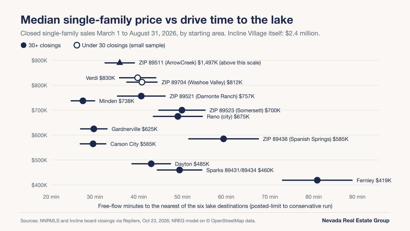
These are single-family medians only, and a median says nothing about a specific home. California-side shore prices are covered in the market report linked above.
How should drive time factor into choosing between these communities?
Start from what you need to reach and work back to a starting point. If the requirement is a weekly trip to Incline Village or the north shore, the starting points that fit best are the south Reno communities along the bottom of the Mt. Rose Highway: ArrowCreek at 32 to 39 minutes and Damonte Ranch at 35 to 46 in our model. The tradeoff is the highway itself: a high point near 8,915 feet, the NDOT Tahoe traction rule and documented closures in 2021 and 2025, when the best alternate from south Reno added about 19 to 26 minutes. If you would rather avoid the highest pass, Carson City reached Incline Village in 33 to 41 minutes over Spooner Summit at about 7,144 feet.
If the requirement is the south shore, Minden and Gardnerville fit best at 25 to 30 and 27 to 33 minutes to Stateline, with a 17-to-23-minute penalty when Kingsbury Grade is the problem. Carson City is 33 to 41 minutes with only a 6-to-8-minute penalty.
If you need both shores about equally, Carson City is the closest starting point where Stateline and Incline Village sit within a minute of each other, both at 33 to 41; Dayton is just as balanced but longer, at 44 to 56, and Washoe Valley's two trips are about three minutes apart.
If the requirement is California's north and west shores, Verdi reached Kings Beach in 36 to 44 minutes over Brockway Summit and Tahoe City in 40 to 48 on a route with no summit at all, though California chain rules and California property rules apply once you cross the line.
Whatever the requirement, drive the route at the hour you would travel, and for any specific home, ask in writing who plows the street and what snow removal costs. The Northern Nevada communities overview is a good place to compare the starting points side by side, and our Reno relocation guide covers the rest of the move.
Frequently Asked Questions
How long is the drive from Reno to Lake Tahoe?
From the Reno Arch, our October 23, 2026 model put Incline Village and Kings Beach at 43 to 55 free-flow minutes, Tahoe City at 48 to 58 and Stateline at 62 to 77, before traffic or weather.
What is the closest Lake Tahoe town to Reno?
Incline Village: 36.3 miles from downtown Reno over the Mt. Rose Highway, tied with Kings Beach on time, and clearly closest from south Reno at 32 to 39 minutes from ArrowCreek.
Does the Mt. Rose Highway close in winter?
It is plowed through winter but closes in severe storms: the upper section from December 23 to 28, 2021, and the highway from February 13 to 15, 2025, after about 60 inches of snow. When it closes, downtown Reno drivers lose about 9 to 10 minutes via Truckee and south Reno drivers about 19 to 26 via Carson City.
Do I need chains to drive to Lake Tahoe from Reno or Carson City?
Not on a dry day, but during chain controls on SR-431, SR-207 and U.S. 50 between Glenbrook and Carson City, NDOT allows only chains, or four-wheel or all-wheel drive with snow tires. California routes follow Caltrans R-1, R-2 and R-3 levels.
Is Lake Tahoe closer to Carson City or to Reno?
Carson City, for five of our six destinations: Sand Harbor in 27 to 32 minutes, Stateline and Incline Village in 33 to 41, against 43 to 55 for downtown Reno's closest stops. Only Tahoe City was quicker from downtown Reno, at 48 to 58 minutes versus 57 to 69.
How far is Lake Tahoe from Minden and Gardnerville?
Minden reached Stateline in 25 to 30 minutes over 17.3 miles and Gardnerville in 27 to 33 minutes over 18.2 miles, both via Kingsbury Grade. If Kingsbury is closed, the U.S. 50 route over Spooner Summit took 41 to 53 and 43 to 56 minutes.
Is there a shuttle from the Reno airport to Lake Tahoe?
Yes. North Lake Tahoe Express serves the north and west shores year-round, booked 24 hours ahead, at $85 per person for one to three riders. South Tahoe Airporter serves Stateline, listed at $32.75 one way on October 23, 2026.
Are homes cheaper the farther you live from Lake Tahoe?
Not reliably. In closings from March 1 to August 31, 2026, Minden had a $737,500 median at 25 to 30 minutes from Stateline, Carson City $565,000 at 27 to 32 minutes from Sand Harbor, and Fernley $419,000 at 73 to 89 minutes from Incline Village. In this sample, distance to the shore does not predict the median.
How can you compare Lake Tahoe access before you buy in Northern Nevada?
Use the main table to shortlist starting points by shore, the detour table to price a closed pass, and the price table to see what the trade buys. Eleven of the 13 starting points sit within an hour of the lake even in the conservative run; what separates them is which shore, which pass and which fallback.
When you are ready to look at specific homes, my team can pull recent closed sales for the exact neighborhood and price band you are considering, so the drive-time trade comes with real prices attached. We are Nevada Real Estate Group, brokered by LPT Realty, and we have represented 9,600+ closings across Nevada. Our Northern Nevada office is at 1755 E Plumb Ln, Suite 241, in Reno, and you can reach the team at (775) 277-2120 or through our contact page.
To keep researching on your own, browse the Reno homes and neighborhood guides, Carson City homes and the Lake Tahoe Nevada homes pages, or compare the lake communities themselves in our ten Lake Tahoe areas compared guide. These drive times were modeled once, on October 23, 2026, from OpenStreetMap data of October 22, 2026, so treat them as a dated baseline rather than a guarantee.
Which Sources Inform This Lake Tahoe Drive-Time Guide?
- Copyright and license (ODbL) — OpenStreetMap Foundation; road data © OpenStreetMap contributors; landmark coordinates via Nominatim, October 23, 2026
- Nevada extract and Northern California extract — Geofabrik; OpenStreetMap data through October 22, 2026, downloaded October 23, 2026
- dijkstra_path documentation — NetworkX, the open-source graph library used for routing
- State Maintained Highways of Nevada: Descriptions and Maps (Description Index), January 2023 — Nevada Department of Transportation; route lengths read October 23, 2026
- Elevation Point Query Service — U.S. Geological Survey, The National Map (3DEP); queried October 23, 2026
- Traction and Chains Requirement Descriptions — Nevada Department of Transportation; read October 23, 2026
- Safe Winter Driving — Nevada Department of Transportation; read October 23, 2026
- Nevada Road Condition Definitions — Nevada 511 (NDOT); read October 23, 2026
- Chain Controls and Chain Installation — California Department of Transportation; read October 23, 2026
- Mt. Rose Highway reopens after being closed since Dec. 23 — South Tahoe Now, December 28, 2021
- Mt. Rose Hwy now open after closure following severe winter storms — KOLO 8 News Now, February 15, 2025
- Ground Transportation — Reno-Tahoe International Airport; read October 23, 2026
- North Lake Tahoe Express schedule and rates flyer — North Lake Tahoe Express; file named 10.13.26, posted October 2026, read October 23, 2026
- Frequently Asked Questions — South Tahoe Airporter; fares from the ticket-price box on the operator's homepage, southtahoeairporter.com, read October 23, 2026
- Sand Harbor, Lake Tahoe Nevada State Park — Nevada Division of State Parks; fees and hours read October 23, 2026
- MLS figures: our own pull of Northern Nevada Regional MLS and Incline Village board data through Repliers on October 23, 2026 (single-family closings March 1 to August 31, 2026, by closing date); not official Sierra Nevada REALTORS or Incline Village REALTORS statistics.